By Canada specialist Jamie
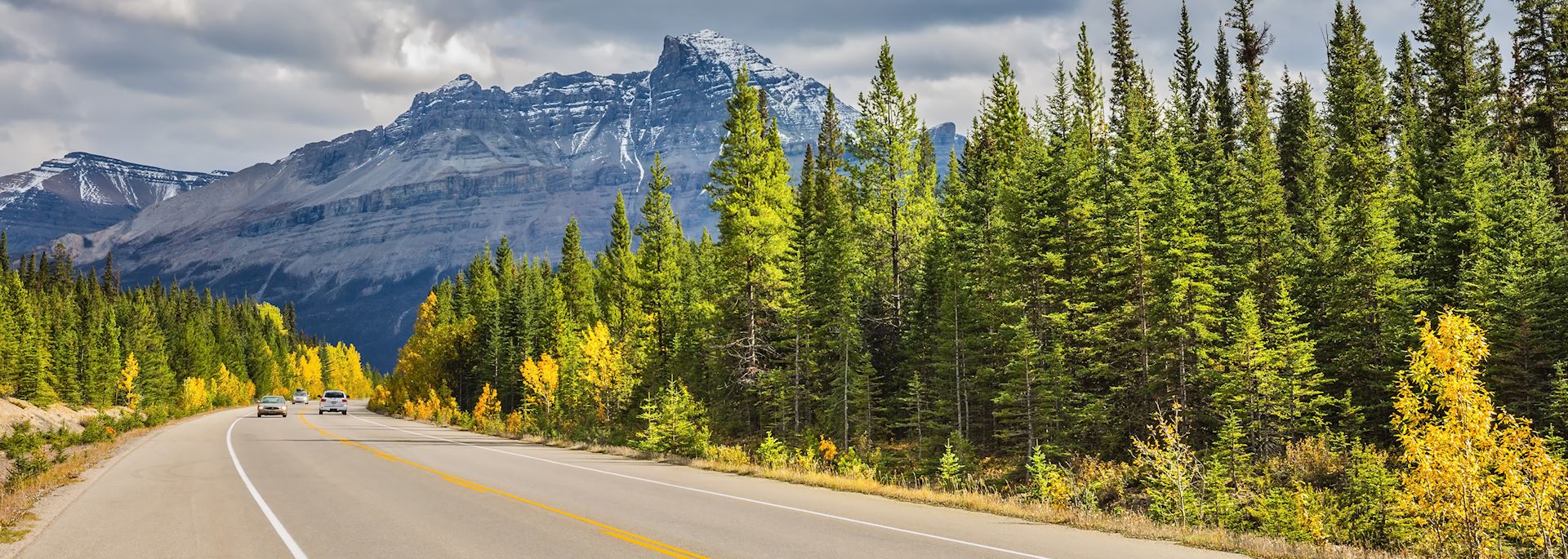
Following the Continental Divide along North America’s backbone, the 233 km (145 mile) Icefields Parkway is one of Canada’s most striking drives. The road links Jasper and Lake Louise in the heart of the Canadian Rockies, cutting through a valley of steep-sided, glacier-clad mountains, rivers that rush through water-smoothed canyons, waterfall-strewn pine forests and emerald lakes.
While it’s possible to drive the parkway in three hours, this is a journey you don’t want to do in a hurry. There are waterfalls to hike to, turquoise lakes to stroll around and elevated viewpoints set up with picnic tables. I recommend dedicating a whole day to the drive as part of a self-drive trip through western Canada.
While it’s rewarding to pull over on a whim when you come across a particularly impressive view or an intriguing hike, there are so many places to stop along the parkway, it’s worth roughly planning your day to make sure you drive at the right pace and don’t miss anything. To help, I’ve outlined some of the route’s best hikes, viewpoints and picnic spots below.
My recommended hikes along the Icefields Parkway
As you drive the parkway’s length, you’ll pass through all three life zones of the Canadian Rockies, from the meadow valley floor, or montane zone, near Jasper, to the thick spruce and fir forests of the subalpine zone and the treeless tundra of the alpine zone.
This constantly changing landscape makes for some excellent hiking opportunities. And, with such a mix of habitats, wildlife is plentiful, from black bears at the side of the road to elk, deer, bighorn sheep and mountain goats in wilder corners.
Upper and Lower Sunwapta Falls

The Upper Sunwapta Falls are located just a few paces from the car park. You can view them from the side and from the bridge that spans the narrow canyon through which the water gushes.
You can then follow a 2.8 km (1.7 mile) return trail through pine forest, following the fast-flowing river. The trees open out every so often, giving you views across to sharp, sometimes-snowy mountain peaks.
The trail descends to the level of the river and you can see the Lower Falls, which comprise three separate waterfalls. Fewer people venture down to these falls, so you can admire the frothing water in peace. The return hike is uphill, so you’ll need a reasonable level of fitness.
Forefield Trail
This flat 2.5 km (1.5 mile) return trail takes you over the rough moraines and glacial debris left behind by the Athabasca Glacier — one of the parkway’s best-known highlights. The landscape is stark and bare, covered in loose gray stones.
You can then continue onto the Toe of the Athabasca Glacier trail, a further 1.4 km (0.9 mile) return trip. You’ll walk over glacially smoothed limestone that was buried beneath the glacier as recently as the 1950s. Follow the trail upwards through one steep section (which is often icy underfoot, so tread carefully) to take in close-up views of the glacier, before tracing your route back to the car park.
Parker Ridge

Following this trail, you’ll climb a series of steep switchbacks through pine trees and meadows, which are dotted with wildflowers in July and August. Eventually, the trees disappear and you’re rewarded with views of the Saskatchewan Glacier — the largest glacier in the Columbia Icefield, one of the most extensive non-polar icefields in the world. The 5.6 km (3.5 mile) return trail is typically snow-covered in June, and wet in July. Note that the hike takes around three hours, so you’ll need to plan it into your day.
My recommended viewpoints and picnic spots along the Icefields Parkway
Athabasca Pass Lookout

From here, you can soak up views over meringue-like mountain peaks (including Mount Edith Cavell, Alberta’s most prominent peak) rising above a forest-covered valley. Interpretation panels tell you about the Athabasca Pass’s role as a 19th-century fur-trade route, which has earned its status as a National Historic Site.
Goats and Glaciers viewpoint and picnic spot
A short uphill walk along a fairly smooth path leads you to a picnic bench with elevated views over the wide Athabasca River, row upon row of pine trees and steep, snow-laced mountains.
Stutfield Glacier
Pull over at this viewpoint to look over at the Stutfield Glacier, which is sandwiched between two mountains. The glacier partially covers a sheer mountain face, and the white ice helps show off the rock’s different strata. In the foreground, you can gaze over the wide, flat river valley with its dense covering of firs. The viewpoint has picnic benches and a telescope for a closer look.
Bridal Veil Falls

You can see this diaphanous waterfall from the road as you drive, or you can pull over for a better look. The thin, wispy stream of water drops down a sheer rock face, fanning out into various cascades as it reaches the lower portion of the rock.
Weeping Wall
This can also be seen from the car, or you can park in the layby. The sheer rock face runs with cascading water in late spring and summer, while in winter the waterfalls freeze, creating pillars of ice often scaled by ice climbers.
Bow Summit

A short, uphill walk from the car park rewards you with views over the turquoise, glacier-fed waters of Peyto Lake. The lake’s named after Bill Peyto, an early guide and park warden of Banff National Park. You’ll also pass through alpine meadows which are dotted with wildflowers in the summer. Bow Summit is the highest point on the Icefields Parkway at 2,088 m (6,800 ft) above sea level.
Bow Lake
Pause at this lake to take in views over the glowing sky-blue, which reflects the surrounding peaks. You can also see Crowfoot Glacier, Crowfoot Mountain, Bow Glacier and the Wapta Icefield. There are picnic benches here if you want a bite to eat.
Other points of interest along the Icefields Parkway
The Columbia Icefield and Athabasca Glacier
The parkway passes the Columbia Icefield. Within it sprawls the Athabasca Glacier, which you can get close to by following the Forefield and Toe of the Athabasca Glacier trails detailed above.
For a more in-depth look at the glacier, I recommend joining a three-hour guided walk on its surface. As you tread the ice (all equipment is provided), your guide will talk about the glacier’s formation, explain how and why it’s retreating, and point out features of the glacially carved landscapes, such as moraines, moulins and small crevasses.
You could also stop off at the Columbia Icefield Centre, a natural history museum with exhibits that detail how glaciers form, grow and retreat.
Athabasca Falls
This is one of the parkway’s more popular stop-off points, so you’re best to time your arrival for early morning, spending around half an hour or so taking in the various viewpoints overlooking the falls as they rage over juts of eroded rock and gush through the canyon.
Interpretation panels tell you about the falls’ formation and the different geological features you can see, such as potholes in the canyon walls and the different strata revealed in the rock by constant erosion. As you stroll down the canyon, signs tell you where the waterfall used to be before its erosion of the rock led to its retreat.
Exploring the Lower Canyon, you can walk along the bottom of an abandoned river channel to the mouth of the Athabasca Falls canyon, where the river spreads out and becomes calm after its turbulent journey (be prepared to climb 59 steps on your return).
Walking in the opposite direction, you can get away from the crowds by following part of the snowshoe route. The trail takes you through pine forest along the edge of the river. Its water runs milky-white in spring and early summer due to the rock flour released by glacial meltwater.
Tips and practical information for driving the Icefields Parkway
- Set off early — you’ll avoid the worst of the traffic, increase your chances of seeing wildlife, and have more time to make the most of your journey.
- Top up your fuel before setting off — there’s one gas station along the parkway, at the Saskatchewan River Crossing Resort 153 km (95 miles) from Jasper, but prices are typically higher than in the towns and there can be queues in summer.
- Pack a lunch — dining options are limited, and there are lots of scenic picnic spots.
- Keep your eyes peeled for wildlife and, if you encounter any, slow down, use your hazard lights and remain in your car. It’s important to give the animal(s) plenty of space.
- Keep to the speed limits, which are usually between 70 and 90 km/h (43 and 56 mph).
- The landscape and things you can do varies depending on the time of year. Up to early June, some of the lakes might still be frozen and trails can sometimes be closed due to snow or maintenance. This will be clearly signposted at the side of the road, so you can simply continue to the next stop. Be prepared for snow at any time of year — check the road reports before you set off, pack extra clothing and drive within the speed limits.
- Public toilets are available at many of the scenic lookouts and points of interest along the parkway. Expect basic facilities with no running water unless you’re at the Icefields Centre or Saskatchewan River Crossing Resort.
- There’s no phone signal, but I think this gives you the opportunity to ‘switch off’ and appreciate your surroundings.
Read more about self-drive trips in western Canada
Start thinking about your experience. These itineraries are simply suggestions for how you could enjoy some of the same experiences as our specialists. They're just for inspiration, because your trip will be created around your particular tastes.
View All Tours in Canada


